
TL;DR:
- Mapping scenic motorcycle routes requires using rider-specific tools like Best Biking Roads, REVER, and Scenic to access community-rated GPX files. Selecting routes that match your skill level involves assessing curves, elevation, surface quality, and traffic to ensure safety and enjoyment. Proper planning of logistics, timing, fuel stops, and offline navigation transforms a scenic ride into a memorable adventure worth lasting years.
Knowing how to map scenic motorcycle routes separates a forgettable weekend ride from one you'll talk about for years. The challenge isn't finding roads that look pretty on paper. It's finding roads that match your skill level, reward your senses, and hold together logistically when you're 200 miles from the nearest town. This guide covers exactly that: the best tools, route selection criteria, trip planning essentials, and a step-by-step process for getting from your driveway to some of the most beautiful rides for bikers anywhere in North America.
Table of Contents
- Key takeaways
- How to map scenic motorcycle routes: the right tools
- Choosing routes that match your skill and goals
- Planning the logistics of your scenic motorcycle trip
- Step-by-step guide to planning and executing your route
- Top scenic routes to inspire your next ride
- My take on what actually makes a scenic route worth riding
- Discover curated rides and events with Bikerslifestyle
- FAQ
Key takeaways
| Point | Details |
|---|---|
| Use rider-curated tools | Community platforms with GPX downloads outperform generic mapping apps for scenic motorcycle trips. |
| Match route to skill level | Choose roads based on curve intensity and elevation, not just reputation or popularity. |
| Plan fuel and timing early | Remote scenic routes require proactive fuel stops and off-peak timing for the best experience. |
| Download offline navigation | Cell coverage drops on the best routes, so offline maps and GPX files are non-negotiable. |
| Tap community knowledge | Rider-shared route updates reflect real current conditions that no app algorithm can replicate. |
How to map scenic motorcycle routes: the right tools
Most riders start with Google Maps or Apple Maps because they're familiar. Both will get you somewhere. Neither will get you anywhere worth riding. Generic mapping software routes you for speed and efficiency, not for curves, elevation drama, or views that make you pull over involuntarily. When you're serious about scenic motorcycle trips, you need tools built specifically for riders.
Community-driven platforms like Best Biking Roads and REVER are the real workhorses here. They aggregate routes submitted and rated by other riders, which means you're getting road knowledge that's been field-tested on two wheels. The Scenic app takes a different approach: it automatically generates twisty, picturesque routes between your start and end points, filtering out highways and prioritizing secondary roads.
GPX files are the format that ties everything together. A GPX file is essentially a GPS track you can download and load directly into your device or app. GPX files from experienced riders allow others to navigate complex scenic routes with confidence, avoiding the pitfalls of relying on generic GPS apps that have never seen a blind hairpin turn.
Here's a quick comparison of the most popular motorcycle route planner options:
| Tool | Best for | GPX support | Cost |
|---|---|---|---|
| Best Biking Roads | Community-rated routes worldwide | Yes | Free/Premium |
| REVER | Route recording and sharing | Yes | Free/Premium |
| Scenic App | Auto-generated twisty routes | Yes | Paid |
| Kurviger | Europe-focused curvy road routing | Yes | Free/Paid |
| MyRouteApp | Multi-stop trip building | Yes | Paid |
Pro Tip: Before committing to a tool, download a short local route in GPX format and load it to your GPS or phone. Testing the workflow on a familiar road saves real frustration on day one of a multi-day trip.
One more consideration: rider-curated routes reflect conditions that algorithms miss entirely. A road that washed out last spring, a section with new gravel, a fuel stop that closed. That's the kind of intelligence community-driven platforms consistently deliver over standard mapping software.
Choosing routes that match your skill and goals
The single biggest mistake riders make when planning scenic motorcycle routes is choosing based on reputation instead of fit. The Tail of the Dragon sounds legendary, and it is. But if you've never ridden sustained technical curves at elevation, showing up to a road with 318 curves over 11 miles is a recipe for white knuckles and no scenery. You'll be too focused on survival to appreciate anything.
Matching route difficulty to rider comfort means honestly evaluating blind corners, steep drop-offs, and curve frequency before you go, not after you're committed mid-mountain. The best motorcycle roads test rider skills with sustained elevation changes and low commercial traffic, offering both challenge and reward in equal measure.
Here's what to evaluate when selecting a route:
- Curves per mile: A high curve density like the Coronado Trail's 460 curves over 120 miles demands constant focus. Lower density routes let you breathe and look around.
- Elevation change: Big climbs and descents increase fatigue and require more active braking. Account for this when estimating daily distance.
- Road surface: Check recent rider reports for gravel, patching, or damage. Forums and apps like REVER often have recent reviews.
- Traffic density: Popular routes on summer weekends turn into parade routes. Low commercial traffic makes a ride exponentially more enjoyable.
- Services available: Gas, food, and lodging frequency matters more on a technical route where you're burning more fuel and mental energy.
Consider three archetypes as reference points. The Blue Ridge Parkway is long, sweeping, and forgiving. It rewards newer riders and tourers with incredible scenery and manageable curves. The Tail of the Dragon is short, intense, and technical. It rewards experienced riders who want a workout. The Coronado Trail in Arizona sits in between: long, remote, and moderately technical with extraordinary payoff for those who prepare properly.
Pro Tip: If you're unsure about a route's difficulty, search for ride reports on forums or YouTube from riders on similar bikes. Watching someone else navigate the road is the closest thing to a preview lap you'll get.
Planning the logistics of your scenic motorcycle trip
A great route ruined by bad logistics is still a bad day. Timing, fuel, distance, and weather are the four variables that separate a memorable trip from a miserable one.

Seasonal timing matters more than you think
Ride timing can make or break a scenic trip. For high mountain passes, late May through October is generally the safe window in the American West and in Europe. Colorado wildflower routes peak from late June through August, which overlaps with the highest traffic. Shoulder seasons, think mid-September in the Rockies, often deliver the best combination of color, cooler temps, and thinner crowds.
Fuel planning on remote routes
Topping off your tank proactively is standard practice on remote scenic routes, and it should be yours too. In Texas Hill Country on the Twisted Sisters loop, gas stations can be 60-plus miles apart. In rural Arizona on the Coronado Trail, that gap widens further. Never assume the next town has a gas station. Never ride past one thinking there's another soon.
Estimating daily distance and trip length
Here's a useful contrast: a Route 66 motorcycle trip typically takes 21 days end to end, covering roughly 2,400 miles with stops. The West Elk Loop in Colorado, a gorgeous 164-mile highway scenic route through canyon country, can be ridden in a single day or stretched into a relaxed weekend. Use this kind of comparison to calibrate how much ground you actually want to cover daily. Most experienced tourers cap themselves at 300 to 400 miles per day on technical roads, not because they can't do more, but because pushing distance kills presence.
A simple logistics checklist for multi-day scenic rides:
- Mark fuel stops every 100 miles, or less on remote routes
- Book overnight stays in advance during peak season
- Download offline maps before each riding day
- Check weather forecasts 48 hours out, not just morning of
- Share your daily itinerary with someone not on the trip
- Identify the nearest emergency services at each overnight stop
Pro Tip: Riding iconic roads at off-peak times like early weekday mornings dramatically reduces traffic stress on popular routes. On the Tail of the Dragon, arriving before 8 a.m. on a Tuesday changes the entire character of the ride.
Step-by-step guide to planning and executing your route
Knowing the tools and the criteria is one thing. Putting them together into an actual plan is where most riders stall out. Here's a process that works, from blank screen to first mile.
Step 1: Define your trip parameters. Decide on start and end points, total days, and a rough daily mileage budget. Also be honest about your skill level. This shapes every decision that follows.
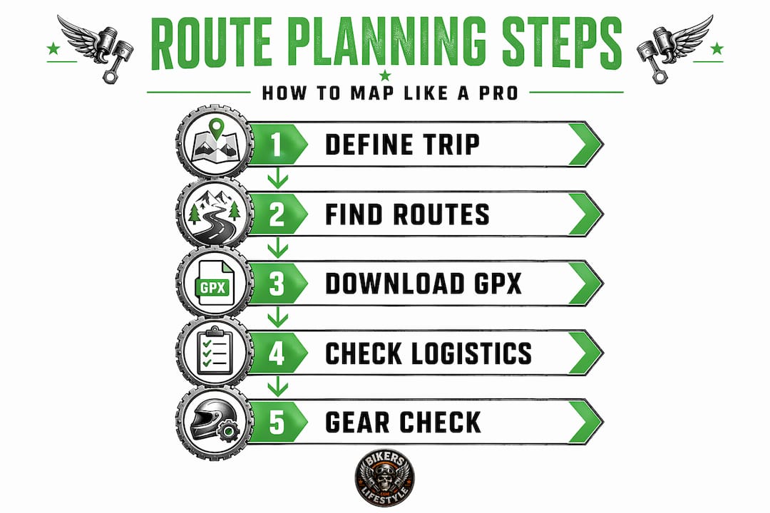
Step 2: Browse community routes. Open Best Biking Roads, REVER, or the Scenic app and search the region. Read rider reviews. Sort by rating and difficulty. Shortlist three or four candidate routes.
Step 3: Download GPX files. For your top candidates, download the GPX files and load them into your preferred GPS device or smartphone app. Verify that the route actually loads and displays correctly before the trip.
Step 4: Cross-check logistics. Overlay your route with fuel station locations, lodging options, and weather patterns for the season. Adjust waypoints as needed to keep fuel gaps manageable.
Step 5: Build your navigation setup. Load the GPX file to your primary navigation device and have a backup. A dedicated GPS unit is more reliable than a phone in heat, rain, or areas with no cell signal. Apps like MyRouteApp provide precise navigation on scenic secondary roads where generic apps lose the plot.
Step 6: Do a gear and safety check. Pack for the terrain and weather you'll actually encounter, not the weather you hope for. High mountain routes can swing 40 degrees from morning to afternoon.
Step 7: Ride with presence, not pace. Once you're out there, resist the urge to chase miles. Pull over for views. Talk to locals. The best motorcycle adventure mapping experience isn't a time trial. It's a sequence of moments you actually let yourself have.
On-road troubleshooting is worth planning for too. If you lose GPS signal on a remote stretch, keep a physical map or pre-downloaded offline version accessible. If you hit an unexpected road closure, most rider apps let you reroute on the fly. Know how to do this before you need to.
- Keep your phone charged with a handlebar-mounted charger
- Save emergency contacts and route files to your device, not just the cloud
- Note mile markers at your last known position if you stop in an area without signal
Top scenic routes to inspire your next ride
The following routes represent the full spectrum of what scenic motorcycle touring looks like, from beginner-friendly to seriously technical.
| Route | Location | Distance | Best Season | Curve Intensity |
|---|---|---|---|---|
| Blue Ridge Parkway | VA to NC | 469 miles | May-Oct | Moderate |
| Tail of the Dragon | NC/TN | 11 miles | Apr-Oct | Extreme |
| Coronado Trail | AZ | 120 miles | Apr-Oct | High |
| Twisted Sisters | TX | ~100 miles | Oct-Apr | High |
| Cabot Trail | Nova Scotia | 185 miles | Jun-Oct | Moderate |
| West Elk Loop | CO | 164 miles | Jun-Sep | Moderate |
A few notes on what makes each one special beyond the stats. The Blue Ridge Parkway is a picturesque bike path with no commercial vehicles and no traffic lights for its entire length. That alone sets the tone. The Cabot Trail in Nova Scotia delivers coastal cliff views that most American riders overlook entirely, making it one of the most underrated top scenic rides on the continent.
For riders who've done the famous routes and want novelty, the West Elk Loop through central Colorado passes through three distinct geographic zones in a single day. The Twisted Sisters loop in Texas Hill Country works best in fall and winter when desert heat isn't a factor and the roads are empty.
Things to note when comparing routes:
- Remoteness affects both scenery quality and risk. Plan accordingly.
- Curve intensity ratings vary by source. Read rider reports, not just official guides.
- Shorter routes like the Tail of the Dragon are often best combined with longer touring corridors.
- Weather windows on mountain routes are narrower than most planning guides suggest.
My take on what actually makes a scenic route worth riding
I've planned and ridden enough routes to say this with conviction: the obsession with famous roads is overrated. Riders spend months preparing for the Tail of the Dragon, show up on a crowded Saturday in July, and spend the whole time managing traffic and adrenaline instead of actually riding. The road is brilliant. The experience on that day? Often disappointing.
What I've found actually works is chasing the quality of the moment, not the name recognition of the road. Some of the best rides I've had were on routes I found through community platforms that had fewer than 50 reviews and no mainstream coverage. The curve counts were solid, the surface was clean, and I had the road entirely to myself.
The other thing I tell every rider I talk to: off-peak timing isn't just a logistical tip. It's a philosophy. Riding technical roads at off-peak times changes the entire experience. Early morning on a weekday, a road that's a parking lot on Saturday becomes your personal proving ground.
I also think riders underestimate the value of community knowledge. The difference between a rider-curated GPX file and a route generated by a general navigation app is the difference between someone who's ridden that road 20 times and an algorithm that's never left a server. Tap into rider communities. Read route reviews. Ask questions in forums before you go. The collective knowledge there is worth more than any single app.
Finally: don't let gear obsession replace route preparation. You need good gear, no question. But I've seen riders with $2,000 helmets and $4,000 jackets arrive completely unprepared for the logistics of a remote route. Know where your fuel is. Know where you're sleeping. Know your route before you trust a GPS to improvise.
— Trevor
Discover curated rides and events with Bikerslifestyle
Planning a scenic motorcycle trip gets a lot easier when you don't have to start from scratch. Bikerslifestyle is built around exactly that. The platform connects riders with community-curated scenic rides, group events, and organized rallies that already have the logistics figured out. Whether you're looking for a weekend loop or a multi-day adventure to add to your calendar, the site surfaces options from riders who've actually done the work of scouting, mapping, and reviewing these roads.
You'll find searchable listings of upcoming rides, active rider groups by region, and route plans you can join or use as a starting point for your own adventure. If group riding is your thing, Bikerslifestyle also lists rallies and events including destination rides like the 2026 European Motorcycle Rally for riders looking to take their touring international. Head to Bikerslifestyle and start building your riding calendar today.
FAQ
What are the best apps to map scenic motorcycle routes?
Rider-focused apps like Best Biking Roads, REVER, and the Scenic app are your best options. They offer community-rated routes and GPX downloads designed specifically for motorcycle touring, unlike general navigation apps.
How do I choose a scenic route that matches my skill level?
Evaluate curves per mile, elevation changes, and road surface before committing to a route. Beginners do well on the Blue Ridge Parkway, while experienced riders looking for intensity can target routes like the Tail of the Dragon or the Coronado Trail.
What is a GPX file and why do I need one?
A GPX file is a GPS track you download from a route planning platform and load directly into your GPS device or navigation app. GPX files from experienced riders provide far more accurate guidance on scenic secondary roads than routes generated by generic mapping software.
When is the best time to ride scenic mountain routes?
For most mountain routes in the U.S. and Europe, late May through October is the recommended window. Colorado wildflower routes peak from late June through August, though shoulder seasons offer lighter traffic and equally stunning scenery.
How far should I plan to ride each day on a scenic motorcycle trip?
Most experienced tourers limit themselves to 300 to 400 miles per day on technical scenic roads. Covering more distance than that tends to reduce the quality of the experience and increases fatigue risk, especially on curvy, elevation-heavy routes.